- Jun 08, 2026
War Damage Across Middle East Visible in Satellite Images After 100 Days of Conflict
- Jun 08, 2026
- International
PNN News Desk. International
Even after 100 days of joint U.S. and Israeli attacks, the full extent of destruction across Iran and surrounding regions has not been fully assessed. However, new satellite imagery shows widespread devastation across the Middle East.
Satellite data from Planet Labs and other monitoring agencies indicates that restrictions were placed on publishing images of certain areas upon request from Washington. Despite this, previously collected data reveals severe destruction.
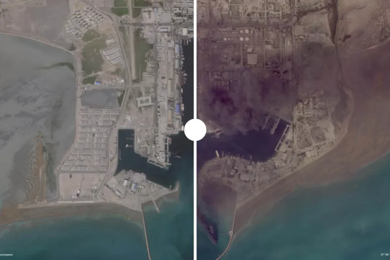
Heavy damage has been observed at Iran’s Natanz nuclear facility and the Fordow site. Significant fires and explosions have also been detected at oil infrastructure on Kharg and Sirri islands.
Damage has been recorded at Bandar Abbas port and the Fatah airbase, including destruction of warehouses, docks, and military facilities.
In southern Lebanon, cities such as Naqoura, Bint Jbeil, Rshaf, and Koza have suffered extensive destruction, with hundreds of buildings damaged or destroyed.
Several military bases across the Gulf region, including Al Udeid in Qatar, Al Salem in Kuwait, Al Dhafra in the UAE, and Prince Sultan Air Base in Saudi Arabia, also show signs of damage.
The headquarters of the U.S. Fifth Fleet in Bahrain has also reportedly suffered structural damage.
Experts warn that the conflict is reshaping geopolitical balance across the region and may further escalate if not controlled.

প্লিজ লগইন পোস্টে মন্তব্য করুন!
আপনিও পছন্দ করতে পারেন


- Jun 08, 2026
Strong Earthquake in Philippines Triggers Tsu...

- Jun 08, 2026
New Diplomatic Tensions Surround Lebanon Amid...

- Jun 04, 2026
US Congress Passes Proposal to Limit Trump’s...

- Jun 04, 2026