- Nov 04, 2026
Israel Expands Control Over Gaza Despite Ceasefire, Restricting Access to 65% of Territory
- Oct 12, 2026
- International
International Desk | PNN
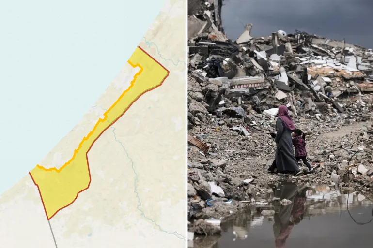
Despite a ceasefire brokered by the United States, Israel is further expanding its military control over the Gaza Strip. The establishment of control in additional areas and the imposition of movement restrictions mean that approximately 65% of Gaza is now under Israeli military control or subject to restricted access. As a result, around 2.1 million Palestinians are being forced to live in an increasingly compressed area of the territory.
According to an analysis by Al Jazeera, the “Yellow Line”—the boundary up to which Israeli troops were supposed to withdraw under the ceasefire—is gradually being moved westward. This is reducing the space available to Palestinians and intensifying displacement and the humanitarian crisis.
On Sunday, Israeli troops moved dozens of yellow concrete marker blocks several dozen metres westward in the Shuja’iyya neighbourhood of southeastern Gaza City. As a result, additional parts of the area came under Israeli military control, forcing Palestinian families to leave their homes.
Ibrahim Al-Khalili, an Al Jazeera journalist reporting from Gaza, said the issue was not simply the current location of the boundary but also how much farther it might be moved in the future. Families displaced repeatedly over the past three years are now left with virtually no choice but to confront the difficult question of where they can find shelter.
Israel launched a major military campaign in Gaza following the Hamas-led attack on southern Israel on October 7, 2023. Since then, the territory has suffered extensive casualties and widespread destruction of infrastructure. According to various United Nations agencies, more than 90% of Gaza’s population has been displaced by Israeli military operations.
Before the war, the Gaza Strip covered approximately 365 square kilometres. The territory was about 41 kilometres long and between six and 12 kilometres wide. Even before the conflict, it was one of the most densely populated areas in the world, with an average of around 6,000 people per square kilometre.
A buffer zone had already existed along Gaza’s border with Israel. According to figures from the UN Office for the Coordination of Humanitarian Affairs (OCHA) in 2010, the restricted area covered approximately 17% of Gaza’s territory and 35% of its agricultural land. A land, air and sea blockade of Gaza has also been in effect since 2007.
Under the first phase of US President Donald Trump’s proposed 20-point plan to end the war, Israeli troops were supposed to withdraw to the Yellow Line within 24 hours of the ceasefire taking effect. However, the arrangement left approximately 53% of Gaza under Israeli control. Palestinians were left with only 47% of the territory, covering around 172 square kilometres.
By October 2025, reports indicated that more than 67,000 Palestinians had been killed during the two-year war. Displacement and population pressure had pushed the population density in the remaining areas of Gaza to approximately 12,000 people per square kilometre.
Even after the ceasefire, Israeli forces have repeatedly moved the Yellow Line’s marker blocks farther west. Satellite imagery has also documented the destruction of buildings and other structures in areas under Israeli control.
According to research organisation Forensic Architecture, approximately 58% of Gaza’s territory was under Israeli control by December last year.
In March this year, the Israeli military provided humanitarian organisations with a map showing another boundary known as the “Orange Line.” Restrictions were imposed requiring organisations to coordinate with the Israeli military before conducting humanitarian operations in certain areas beyond this boundary.
According to OCHA, access to approximately 65% of Gaza is currently restricted. Meanwhile, a UN official told the Security Council in June that Israel itself had stated it controlled around 70% of the territory.
As a result, approximately 2.1 million people are being forced to live within just 35% of Gaza’s territory, an area measuring roughly 128 square kilometres. The population density there has risen to approximately 16,000 people per square kilometre, nearly three times the pre-war level.
Under the current conditions, approximately 61 square metres of land remain available per person on average. Homes, roads, schools, hospitals and agricultural land must all fit within this severely limited space.
According to the United Nations Satellite Centre (UNOSAT), 82% of Gaza’s buildings have been damaged or completely destroyed. The UN Food and Agriculture Organization estimates that only 3% of the territory’s agricultural land remains both intact and usable.
OCHA says the remaining 35% of Gaza is already severely overcrowded. With the rainy season approaching, humanitarian workers are attempting to move displaced families to safer locations. However, movement restrictions and a lack of available space are major obstacles to these efforts.
According to UN figures, more than 950,000 people in Gaza are living in temporary shelters at risk of flooding and waterlogging during periods of heavy rain. Many are staying in tents or makeshift accommodation.
Approaching the Yellow Line has also become potentially fatal for Palestinians in several parts of Gaza. According to Al Jazeera, Israeli forces treat areas beyond the boundary as zones where people risk being shot. Palestinians have reportedly been shot for approaching these areas.
The report states that approximately 1,500 people have been killed across Gaza since the ceasefire was announced. The continued expansion of military control, ongoing displacement and obstacles to delivering humanitarian aid are further worsening the crisis across the territory.

প্লিজ লগইন পোস্টে মন্তব্য করুন!
আপনিও পছন্দ করতে পারেন


- Nov 04, 2026
Republicans Suffer Major Defeat as Democrats...

- Nov 04, 2026
Democrats Win Control of Both Chambers of US...

- Nov 04, 2026
Abdul El-Sayed Set to Become First Muslim US...

- Oct 31, 2026